Towards a more sustainable agriculture
Excessive use of fertilizers is now recognised as playing a major role in environmental degradation and is encouraging farmers to improve their management of these fertilizers. Nitrogen application rates can be optimized at field level according to the crop needs. Good nitrogen input management practices have many economic and environmental benefits (runoff, leaching,...) and can increase the yield and quality of the crop.
A new generation of European satellites for agricultural monitoring
Since 2016, the emergence of a new generation of satellite sensors with high spatial and temporal resolution (including Sentinel-1, Sentinel-2 and PROBA-V) has paved the way for the development of new prototypes of innovative agricultural management support applications that are more connected to their end users.
Accelerating the information loop between users and suppliers
Based on the most recent innovations in remote sensing and Information and Communication Technology (ICT), the research challenge is to profoundly modify the interactions between users and producers of information. It is also a question of significantly accelerating the critical learning process for suppliers of remote sensing technologies through input and feedback from users.
Objectives
The main objective of the project was to develop remote sensing methods and processing chains capable of integrating data provided by farmers or associated partners, on a voluntary basis or on the basis of an exchange of information services. This enables the delivery of relevant and up-to-date information at both field and district level. The information chain involves satellites, researchers developing methods, pilot and technical centers and farmers.
The methods developed aimed to determine by satellite remote sensing useful variables for agricultural monitoring at field level, such as leaf area index, chlorophyll concentration, nitrogen content or biomass. The aim was also to identify the sources of variability explaining the prediction performance of the different variables.
Finally, the improvement of classical yield models through the assimilation of satellite information was evaluated.
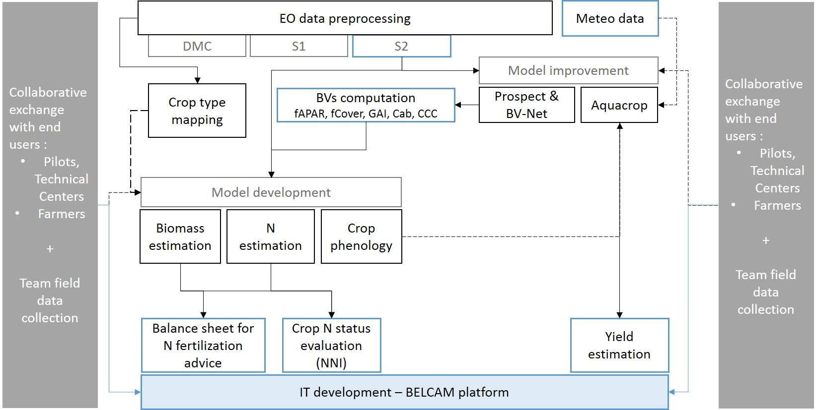
Below is a general outline of the processes involved in BELCAM, from raw satellite data to the various products developed for use on the online platform.

The BELCAM platform supports the continuous improvement of remote sensing products.
The main outcome of this project is a prototype of the "Collaborative Observation System for Belgian Agriculture": the BELCAM platform. The BELCAM platform is designed to enable the continuous improvement of remote sensing products in order to, on one hand, advise farmers at field level and, on the other hand, contribute to agricultural services by providing an a posteriori analysis of the growing season (evaluation of stresses, diseases and impact study according to the regions).
Satellite information for everyone thanks to the BELCAM platform
The online platform facilitates access to satellite information for farmers and management structures. The platform is supported by public and scientific institutions and is neutral, independent, open, free of charge and attentive to farmers needs.
This platform supply :
- Pre-processed raw satellite images, with visible and near-infrared images displayed
- Local agro-meteorological data
- A monitoring of crop growth at the field level based on a green biomass index and a comparison with the development of fields within a radius of 4km².
- Yield estimations (wheat, maize, potato) using satellite information.
- The nitrogen status of winter wheat and potato (to come) at field level, through the estimation of the nitrogen content and the Nitrogen Nutrition Index (NNI). These indicators can be used to improve the management of nitrogen fertilisation during the growing season when the total nitrogen supply is splitted.
- Two existing nitrogen recommendation tools based on the balance sheet method: REQUAFERTI and the “Livre Blanc Cereales”. The objective is to replace part of the inputs values by remote sensing estimations to make them more objective. This is the case of winter cover crop biomass, whose estimation was assessed during the project. The identification of the main crop and winter cover crop were also assessed.
Useful links
- The BELCAM platform
- The BELCAM project on BELSPO website
- BELCAM on Digital Wallonia
- BELCAM in the Sillon belge
- BELCAM in the CRA-W info
Contribution
- Preparation and implementation of field campaigns and analysis of field samples (sample processing and infra-red analysis)
- Development of remote sensing models
- Conceptualization of the online platform
- Content of the online platform
- Organisation of meetings with platform users (pilot and technical centres, farmers)
- Presentations at numerous conferences and agricultural fairs
- Production of scientific publications and promotional and vulgarisation documents
Partners
- Université catholique de Louvain (UCLouvain), Earth and Life Institute / Environmental science (ELI-e) : Pierre Defourny
- Flemish institute for technological research (VITO) - Remote Sensing Unit : Isabelle Piccard
- Université de Liège (ULg), Département des Sciences et Gestion de l’Environnement - Campus Arlon : Bernard Tychon
- Institut National de la Recherche Agronomique (INRA)
Coordinator
Prof. Pierre Defourny
Université catholique de Louvain (UCL)
Earth and Life Institute / Environmental science (ELI-e)
Croix du Sud 2, bte L7.05.16, 1348 Louvain-la-Neuve


